Crop and pasture reports
The Department of Primary Industries and Regions (PIRSA) publishes regular reports on the condition of crops and pastures in South Australia. The report provides the estimates of the area and the production for each crop and district during the cropping season.
Crop estimates are based on information provided to PIRSA and are updated throughout the season as conditions change and further information becomes available. They provide an indication of crop potential at the time the report is prepared.
Latest report

South Australian Crop and Pasture Report:
2026–27 Seeding Intentions
Summary
- Good early rainfall in 2026 has seeding underway, with multiple associated benefits that are a substantial improvement on recent years at this time:
- The rain has enabled growers to enter the season with stored soil moisture for the first time in several years.
- Spraying operations have focussed on controlling volunteers and summer weeds to manage the green bridge, and there has been a germination of key in-crop weeds providing an opportunity for knockdown control ahead of seeding.
- The rain has also reduced the risk of herbicide residue carryover in many paddocks and will provide better conditions for pre-emergent herbicide activity.
- Mice and locusts are key risks this season:
- Increasing mouse activity is evident across parts of the Adelaide Plains, Yorke Peninsula and Mid North.
- Australian plague locusts have been reported in several cropping regions and pose a potential threat to early emerging crops.
- Monitoring and baiting programs are ongoing as crops are sown.
- Ongoing supply chain disruption is creating concern among growers, with uncertainty about availability of fuel, fertiliser and crop protection inputs.
- Rising freight costs and higher input prices are likely to put pressure on tight margins and profitability. Despite this, there have been only minor changes to cropping program plans.
- The preliminary estimation of total cropped area is higher than the 2025–26 season. An early break to the season has seen increased planting in more marginal areas of the state. Dry starts in recent seasons precluded this.
- Wheat and barley continue to be the dominant crops.
- Wheat area is similar to 2025–26 and close to the 5-year average, while barley area has increased slightly.
- Durum has rebounded from a lower area sown last year to be close to its 5-year average.
- Lentil area is forecast to increase again, by an additional 12% across the state compared to the 2025–26 season. This firmly establishes lentils as the third largest crop area behind wheat and barley.
- The area sown to canola has increased by 5% compared to season 2025–26.
- As seeding continues, grain production for 2026–27 is estimated to be 9.0 million tonnes, based on the assumption that yield potential is close to the 10-year average. Achieving average yields will ultimately depend on growing season rainfall and the impact of any in season stress events.
- For livestock, rainfall has significantly improved pasture growth and feed availability, supporting a return to near average feed on offer in many areas. As a result, livestock condition has improved with reduced pressure on producers.
- Follow up rainfall will be critical to maintain pasture persistence, particularly for annual species.
- Despite the improvement, supplementary feeding remains important in some regions as producers cautiously manage recovery following earlier dry conditions.
Crop and pasture report dashboard
The PIRSA crop and pasture report dashboard displays crop area and production data, providing a simple source of crop statistical information.
South Australian crop area, production, and yield are searchable by reporting district, crop type, and season.
The data dates from the 1999–2000 season, up to and including the current season.
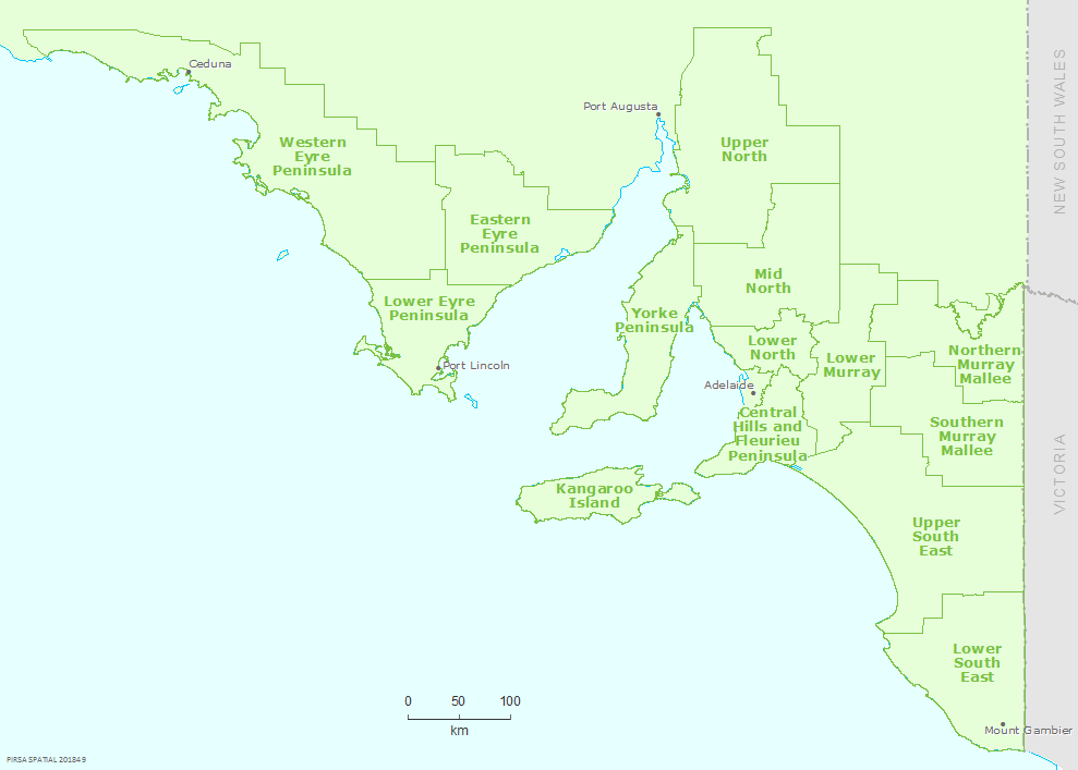
Crop reporting districts
Crop estimates for a season are based on the folowing districts as shown in the map below:
- Western Eyre Peninsula
- Eastern Eyre Peninsula
- Lower Eyre Peninsula
- Yourke Peninsula
- Upper North
- Mid North
- Lower North
- Central Hills and Fleurieu Peninsula
- Kangaroo Island
- Lower Murray
- Nortern Murray Mallee
- Southern Murray Mallee
- Upper South East
- Lower South East
Older reports
2025–26
- 2025–26 Crop Performance Summary ( )
- 2025–26 Spring Crop Performance ( )
- 2025–26 Winter Crop Performance ( )
- 2025–26 Crop Emergence ( )
- 2025–26 Seeding Intentions ( )
2024–25
- 2024–25 Post Harvest ( )
- 2024–25 Crop Performance Summary ( )
- 2024–25 Spring Crop Performance ( )
- 2024–25 Winter Crop Emergence ( )
- 2024–25 Crop Emergence ( )
- 2024–25 Seeding Intentions ( )
2023–24
- 2023–24 Spring Crop Performance ( )
- 2023–24 Winter Crop Performance ( )
- 2023–24 Crop Establishment ( )
- 2023–24 Seeding Intentions ( )